OS 6"26
Situated in the townland of the same name just outside the village of Stepaside, on a side road. Standing high up on a steep mound and visible from the main road, the church, now in ruins, was one of several built by Archbishop King when he came over in 1702 to find scarcely a church in his diocese fit for use. This was built in 1703-7 to serve the parishes of Taney and Cruagh.1 It stands on the site of a Celtic church first mentioned in 1179 as Technabretnach, translated in 1530 by Archbishop Alen in a note as "the house of the Welshmen (called Kilgobbin)".
Who was the founder? Could he have been the Kerry saint, son of Erc (or End) and Mor, sister of St David of Wales who, as well as a church bearing his name, Kilgobbain, on the shores of Tralee Bay, is said to have founded a monastery in Kinsale beside his brother's church, St Multose?2
In 1615 the Regal Visitation found both church and chancel in ruins - not to be replaced for nearly 100 years. In 1824 the neighbouring parish of Kilternan, united with Bray as its church, too, was a ruin, left the Union and joined Kilgobbin. By this time Archbishop King's church was itself in a very bad state and, in 1826, the new church of Kilternan was built and the two parishes united.
Kilgobbin Cross (Nat. Mon.)
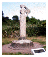
At a little distance from the foot of the hill on which the church stands, is a ringed cross of granite 2.44m in height. The Crucifixion in low relief may just be seen on the E. face. On the W. face, if the light is favourable or if you are lucky with a photograph, the figure may dimly be made out, clothed in the long garment down to the ankles which is usually taken as indicative of an early date, more or less as seen in a drawing by T.J. Westropp.3
The cross is said to have been discovered buried in the graveyard, about the middle of the last century, when it was erected where it now stands,4 the shaft morticed into a large boulder which has a "bullaun" on the SW side. Most unfortunately, it has been damaged at some time, the S. arm broken off and missing.
54. Jamestown
OS 6" 26 Dublin
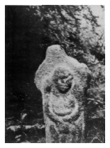
In the townland of the same name the Jamestown cross stands on an ancient causeway or road roughly half way between the Stepaside-Golden Ball and the Carrickmines-Sandyford roads. Access (obtained by permission of the County Council which now owns the land on which a golf course is being laid out) is by a gateway and drive to the office from the Stepaside-Golden-Ball road, thence across two fields to the causeway.
This ancient way is shaded by trees, kept wet by a sluggish stream and muddy from the feet of cattle seeking shelter and water, and can bear a slightly sinister aspect which the cross does nothing to dispel. Clumsy and ill-formed, it measures 1.22m high and 61cm across the arms and bears on one side the figure of an old man, head sunk on his shoulders and apparently seated (in a photograph which I took) although I am assured that his legs are full length when the cross is raised. In the photo he looks sad and pathetic but not sinister. On the other side where only a circle and mouldings were formerly seen, some find another figure today.
O'Reilly who did so much work on this "extremely curious cross" and its neighbourhood, realised that Jamestown was not a very old name and certainly did not appear in early Church records although there were distinct signs of an ancient graveyard and therefore church nearby. In a fine piece of detective work he discovered that the former name of the townland was Ballymochain which instantly gave him the clue to the original dedication of the cross and well, namely, St Caoin, brother of St Kevin of Glendalough.l
St Caoin's feast day is May 1st, the day on which pilgrims visited the cross and well. It is also that of St James on whose feast day the rent had long ago been due. So it seemed clear that when the name St Caoin had been forgotten, but not the day, St James took his place and gave his name to the townland, cross and well.
Reference
1. JRSAI, vol XXxi, Part 2, 1901ÑO'Reilly "Christian Sepulchral Leacs & Free Standing Crosses in the Dublin Half-Barony of Rathdown".
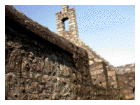
59. Kilgobbin Castle
OS 6" 26 Dublin
Situated a few hundred yards from the village of Stepaside in the grounds of a private house on the left side of the road to Sandyford.
This is another of the upright rectangular castles of the Pale, 2 storeys high over the ground floor and formerly with a thatched roof. The walls, 1.22m thick, on the S. and W. sides, rise to their full height, but most of the other 2 sides have fallen. Built of granite, the stones are somewhat irregular in shape and size.~ A stair tower, square in plan, projects at the SE corner; at the NW the slight remains of an arch may be all that survives of an arched gateway as at Bullock Castle.
The first settlers here were the Harolds, dubbed by a contemporary "noisome neighbours to Dublin" on account of their constant burning and pillaging raids. They were succeeded by the Walshs who probably built the castle as it was before its destruction. They were here throughout the 15th century, but appear to have forfeited Kilgobbin in the 17th century, even before the Rebellion. It was then given by the Crown to Adam Loftus of Rathfarnham, grandson of the Archbishop. The castle eventually became a rebel stronghold during the tenancy of Matthew Talbot at the time of the Rebellion in 1641. It was stormed and captured by General Monk and garrisoned by his company.2 To this day, a field just beyond and to the N. of the castle is called locally "the Battlefield", and cannon balls are said to be dug up from time to time.